A broad surge of unusually warm air is expected to settle over large portions of the United States this Christmas week, creating conditions that could rival some of the warmest holidays ever recorded in parts of the country.
While severe storms continue to impact California and bring intermittent disruptions to the Northeast, meteorologists say a strong ridge in the jet stream will allow a “bubble” of warmth to expand across the south-central U.S. and surrounding regions. The shift marks a dramatic change from earlier this month, when Arctic air pushed south due to a weakened polar vortex.
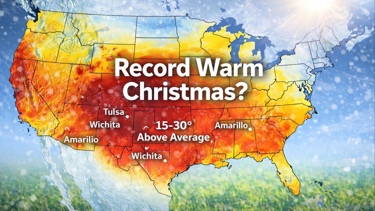
Forecast models indicate that nearly two dozen states could experience temperatures 15 to 30 degrees above seasonal averages by Christmas Day. Areas stretching from the Rockies through the Plains and into parts of the Midwest and Appalachians are expected to feel conditions more typical of late April or early May.
Record-Breaking Temperatures Likely on Christmas Day
Meteorologists say Christmas Day itself may produce the highest number of tied or broken temperature records of the entire week. Cities such as Tulsa, Wichita, Albuquerque, and Amarillo are among those expected to approach or exceed historic highs.
In Oklahoma City, forecasters expect a multi-day stretch of near-record warmth. Average highs for late December typically sit in the upper 40s, but temperatures this week are projected to reach the upper 70s, putting the city roughly 30 degrees above normal.
Experts note that this level of warmth is unusual even outside of holiday periods and could make this Christmas among the warmest some residents have ever experienced.
Warm Nights May Also Challenge Records
In addition to daytime heat, overnight temperatures could also break records in several locations. Some areas may see record-high minimum temperatures, meaning nights remain unusually warm instead of cooling down.
According to meteorologists, some of the records at risk date back to the mid-1900s or earlier, increasing the likelihood that this could be a once-in-a-generation Christmas warmth event for certain regions.
Fog and Low Clouds Could Limit Warmth in Some Areas
The same weather pattern responsible for transporting warm air northward will also pull moisture from the Gulf of Mexico. As a result, low clouds and dense fog may develop from the Gulf Coast through the Ohio Valley, parts of the Appalachians, and along the Atlantic coast.
Where clouds persist, temperatures could be held 10 to 20 degrees lower than forecast highs. Fog may also lead to travel delays, particularly for motorists and airline operations during the busy holiday period.
Northeast and Upper Midwest Likely to Miss the Warm-Up
Despite the widespread warmth elsewhere, the Northeast and Upper Midwest are expected to see limited or short-lived warming. Frequent fast-moving clipper systems are forecast to dive southward from Canada, reinforcing cooler air and preventing prolonged temperature increases.
Forecasters say any brief warm spells in those regions are likely to be interrupted quickly by returning cold air.
Read Also: Maryland Weather Alert: Wintry Mix Could Sneak In Early Tuesday
Unusual Holiday Pattern Continues Nationwide
Overall, the developing weather pattern underscores the sharp contrasts expected across the country this Christmas week — from flooding rains and mountain snow in the West to spring-like warmth across the central and southern U.S.
Meteorologists continue to monitor how far east the warmth will expand and how cloud cover may influence temperatures as the holiday approaches.